Axiom Grid LLC · Malheur County, Oregon

How far can
a corridor go?

From raw high-desert land to an energized, interconnected qualifying facility. Scroll to make the journey. 371± acres. 32+ MW Phase 1. One corridor.

01 · The Land

371± acres of high-desert corridor

Three contiguous holdings along the Malheur River at Harper, assembled into one generation site with US 20 frontage.

02 · The Site

Infrastructure most greenfields never have

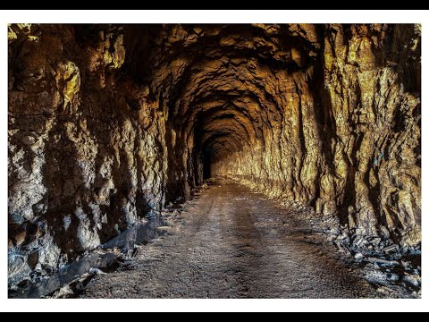
A 3,000-ft basalt tunnel, internal springs, a 1.45M-gallon reservoir, and four private steel bridges — already in the ground.

03 · The Build

32+ MW Phase 1 on the corridor bench

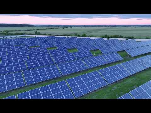
Roughly 70,000 single-axis tracked modules along a rail-grade roadbed engineered for heavy equipment.

04 · The Panels

~26% estimated capacity factor

Eastern Oregon irradiance with cool ambient temperatures — 300+ days of usable sun keeping cells efficient.

05 · The Storage

50,000+ sq ft of hardened, naturally cooled interior

The basalt tunnel holds 55–60°F year-round — a natural thermal envelope for BESS, inverters, and controls.

06 · The Flow

PURPA Qualifying Facility

Standard-contract offtake framework with Idaho Power as the interconnecting utility. Pre-application engaged.

07 · The Grid

Energized. Interconnected. Held for life of asset.

Scaling from 32+ MW Phase 1 to an 80+ MW full buildout — owned and operated, not flipped.

Scroll
371±acres of site control
32+ MWPhase 1 · scaling to 80+ MW
PURPA QFIdaho Power interconnection
BESS-ready50,000+ sq ft hardened interior

$5.29M acquisition financing.
Closing 2026.

Request the Data Room
0MW-ac
Total planned buildout
0MW-ac
Phase 1 nameplate
0MWh/yr
Est. output at full buildout
~0
Oregon homes at full buildout
0± acres
Combined site control
01 · Why Harper

The desert does the work

Three contiguous holdings along the Malheur River, assembled into one generation site.

SOLAR RESOURCE

High desert irradiance

Eastern Oregon's dry, high-elevation plateau delivers some of the strongest and most consistent solar resource in the Pacific Northwest, with cool ambient temperatures that keep panels efficient.

300+ days of usable sun · ~26% est. capacity factor
WATER & HYDRO

Embedded water assets

Natural springs flowing 30 to 40 gallons per minute inside the corridor, a 1.45M gallon internal reservoir, and Malheur River frontage give the project a water and hydro dimension few solar sites can claim.

43,000 to 57,000 gal/day spring output
ACCESS

US 20 frontage

Direct frontage on US Highway 20 plus a full-length rail-grade roadbed means heavy equipment, modules, and O&M crews move on and off site without new road construction.

7-mile private corridor · 4 steel bridges
GRID PATH

Qualifying facility

The project is structured as a PURPA Qualifying Facility, with the interconnection process underway with Idaho Power and standard-contract pricing frameworks in place.

Idaho Power pre-application engaged
HARD ASSETS

Basalt infrastructure

A 3,000-foot hardened tunnel bored through solid volcanic basalt anchors the corridor: 50,000+ square feet of naturally cooled interior space suited to storage, controls, and secure operations.

~55–60°F ambient, year round
SCALE

Room for Phase 2

Phase 1 runs the Malheur corridor. Phase 2 converts the farm ground to solar and carries the buildout to 80+ MW total, with the existing dwelling and outbuildings retained as project offices and storage.

80+ MW planned across phases
02 · The Land

371 acres, in three dimensions

Two views of the Harper site: a stylized model and real satellite terrain. Click any parcel for details.

Drag to rotate · Scroll to zoom · Click a parcel
Model is illustrative and satellite-view outlines are approximate placements for orientation, not survey boundaries. Satellite imagery © Esri; elevation tiles © Mapzen / AWS Terrain Tiles.
03 · On the Ground

The asset, photographed

Site documentation from the corridor walkthrough. Click any image to view full size.

Bridge · River Steel rail bridge crossing the Malheur River inside the corridor
Private steel bridge and diversion works on the Malheur, one of four crossings
Portal Basalt tunnel portal entrance
Tunnel portal at the basalt spur
Tunnel · Springs Interior of the basalt tunnel with internal spring water
Internal springs and the standing reservoir inside the bore
Tunnel · Bore Basalt tunnel interior showing bore dimensions
18 ft × 25 ft bore through solid basalt
▶ Site Video
▶ Site Video
Rail Grade Rail-grade roadbed running through high desert corridor
Full-length rail-grade roadbed on the corridor
04 · Generation

What the site produces

Preliminary estimates from regional resource data. Final figures follow interconnection studies and detailed design.

Utility solar

32+ MW-ac · ~73,000 MWh/yr

Roughly 70,000 single-axis tracked modules along the Phase 1 corridor bench. At an estimated 26% capacity factor, annual output is enough for about 6,700 Oregon homes, delivered under PURPA standard-contract frameworks with Idaho Power as the interconnecting utility and targeted offtaker.

Micro-hydro potential

Continuous base-load supplement

Springs emerge directly from the basalt overhead inside the tunnel at 30 to 40 gallons per minute. With the 25-foot ceiling height, a ceiling-capture drop to a floor turbine can generate silent, continuous power for site loads, independent of sun or wind.

Storage-ready

50,000+ sq ft hardened interior

The basalt tunnel holds a stable 55 to 60 degrees year round, a natural thermal envelope for battery energy storage, inverter controls, and secure operations, with the 1.45M gallon internal reservoir available as thermal mass or managed reserve.

Phase 2 expansion

Farm conversion · 80+ MW total

Phase 2 converts the 169.56-acre farm site and the north parcel to solar, carrying the project from the corridor-based 32+ MW Phase 1 to a planned 80+ MW total. The farm dwelling and outbuildings are retained as project offices, storage, and the O&M base.

Estimated monthly output · MWh
Phase 1 · 32+ MW-ac · ~73,000 MWh/yr
Seasonal shape modeled on Eastern Oregon high-desert irradiance at 43.9° N. Hover a month for the estimate. Full-buildout figures are concept estimates ahead of interconnection studies.
05 · Timeline

Where the project stands

Complete

Site identified

Three contiguous holdings assembled along the Malheur River at Harper.

Complete

QF pre-application

Interconnection pre-application engaged with Idaho Power.

Summer 2026

Site control & LOI

Letter of intent and structured acquisition framework in progress.

Next

Interconnection studies

Feasibility and system impact studies with Idaho Power.

Following

Financing & NTP

Capital close and notice to proceed on Phase 1 construction.

Target

Commercial operation

Phase 1 energized and delivering under contract.

06 · Investor Access

The full picture, for qualified parties

Parcel-level detail, capital structure, and data room access are reserved for parties under discussion. Enter your access code, or reach out to request one.

No code? Contact [email protected] to request access.

Unlocked · Confidential

Site & structure detail

Shared for discussion purposes. Full diligence materials live in the data room.

Parcel schedule

Parcel 8936 · 4120 US 20 Hwy169.56 ac
Parcel 8779 · T20S R40E36.96 ac
River corridor · 7-mi linear165 ac
Combined footprint371.52 ac
Zoning, all parcelsC-A2 Exclusive Range
WatershedHog Cr–Lower Malheur

Improvements & assets

Dwelling, 3bd/2ba on 89362,390 sq ft
Basalt tunnel, 18 ft × 25 ft3,000 lf
Interior hardened space50,000+ sq ft
Internal spring flow30–40 GPM
Internal reservoir~1.45M gal
Private steel bridges4

Structure & contact

Axiom Grid LLC, a Delaware special purpose vehicle under Kuester-Kamara Investment LLC, holds the project. Acquisition supports a structured build-to-spec framework with seller financing available to qualified principals. Capital formation conversations are active. Interconnection and PURPA offtake are in process with Idaho Power.

Data room: [email protected]

Production, emissions, and home-equivalent figures are preliminary estimates derived from regional solar resource data and standard conversion factors. They are subject to interconnection studies, final engineering, and executed agreements. Nothing on this page is an offer to sell securities. Terrain model is illustrative and not survey data.